Cartes
Scientific Research on Tropical Peatland in the DRC Credit: Kevin McElvaney/Greenpeace
Cartes interactives
Pour visualiser les résultats de la carte CongoPeat via le portail interactif UN Biodiversity Lab, avec plus de 150 autres ensembles de données :
- visitez https://map.unbiodiversitylab.org/
- saisissez « CongoPeat » dans le champ de recherche « Layers » pour trouver la carte
- pour obtenir de l’aide, voir https://unbiodiversitylab.org/fr/support/
Jeux de données spatiales
Pour télécharger les jeux de données spatiales à utiliser dans un SIG, veuillez consulter les liens ci-dessous. Veuillez citer les articles pertinents si vous utilisez les données cartographiques.
Crezee, B., Dargie, G.C., Ewango, C.E.N., Mitchard, E.T.A., Emba B., O., Kanyama T., J., Bola, P., Ndjango, J.B.N., Girkin, N.T., Bocko, Y.E., Ifo, S.A., Hubau, W., Seidensticker, D., Batumike, R., Imani, G., Cuni-Sanchez, A., Kiahtipes, C.A., Lebamba, J., Wotzka, H.P., Bean, H., Baker, T.R., Baird, A.J., Boom, A., Morris, P.J., Page, S.E., Lawson, I.T., Lewis, S.L. 2022. Mapping peat thickness and carbon stocks of the central Congo Basin using field data. Nature Geoscience.
- Landcover Probability Layers (5x) – 50m resolution – Geotif – 261 MB (Zipped)
Metadata Landcover probability layers - Unsmoothed Landcover Classification: Most Likely class – 50m – Geotif – 860 MB
Metadata Unsmoothed landcover classification - Smoothed (7×7) Landcover Classification: Most likely class – 50m – Geotif – 860 MB
Metadata Smoothed landcover classification - Median Peat Thickness RF model from 100 runs – 50m – Geotif – 3GB
Metadata Median peat thickness RF model - Uncertainty Peat Thickness RF model from 100 runs – 50m – Geotif – 1GB
Metadata Uncertainty peat thickness RF model - Median Carbon Density from 2000 runs – 50m – Geotif – 3GB
Metadata Median carbon density - Uncertainty Carbon Density from 2000 runs – 50m – Geotif – 1GB
Metadata Uncertainty carbon density - Map comparison – 50m – Geotif – 1.68 GB
Metadata 2022 Map comparison
Dargie, G.C., Lawson, I.T., Rayden, T.J., Miles, L., Mitchard, E.T.A., Page, S.E., Bocko, Y.E., Ifo, S.A., Lewis, S.L. 2018. Congo Basin peatlands: threats and conservation priorities. Mitigation and Adaptation Strategies for Global Change. 24(4), pp.669–686.
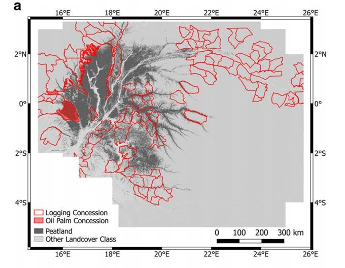
- Map of peatland distribution within the Cuvette Centrale (dark grey; Dargie et al. 2017), overlaid with the locations of logging (red outline; Global Forest Watch 2017c, d) and oil palm (red fill; The Rainforest Foundation UK 2013) concessions. JPEG.
Dargie, G.C., Lewis, S.L., Lawson, I.T., Mitchard, E.T.A., Bocko, Y.E., Ifo, S.A. 2017. Age, extent and carbon storage of the central Congo Basin peatland complex. Nature. 542(7639), pp.86-90.
- Combined classification and probability map – 50m resolution – Geotif – 124 MB
Metadata - Simplified Peat Area image maps (not GIS files) – Two vegetation types with peat combined – With country boundaries – Various zoom levels – PNG – 3 MB
Metadata - Simplified Peat Area Maps (GIS files) – two vegetation types with peat combined – 50 m – Geotif – 8 MB
Metadata - Simplified Peat Area Maps (GIS files) – vegetation types with peat combined – 100 m – Geotif – 3 MB
Metadata - Probability layers of the 5 landcover types (GIS files) as published – 50 m – Geotif
Metadata
The files were created by Greta Dargie and Edward Mitchard. For questions about these data layers please contact Edward Mitchard, email: [email protected]
Dargie, G.C., Lewis, S.L., Lawson, I.T., Mitchard, E.T.A., Bocko, Y.E., Ifo, S.A. 2017. Age, extent and carbon storage of the central Congo Basin peatland complex. Nature. 542(7639), pp.86-90.
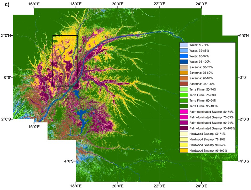
- Probability map of vegetation types derived from 1,000 runs of a maximum likelihood classification using eight remote sensing products (three ALOS PALSAR; two SRTM-derived variables; three Landsat ETM+ bands) and jack-knifed selections of training data. Field observations show that peat underlies both hardwood tree-and palm-dominated swamp forest. PNG.